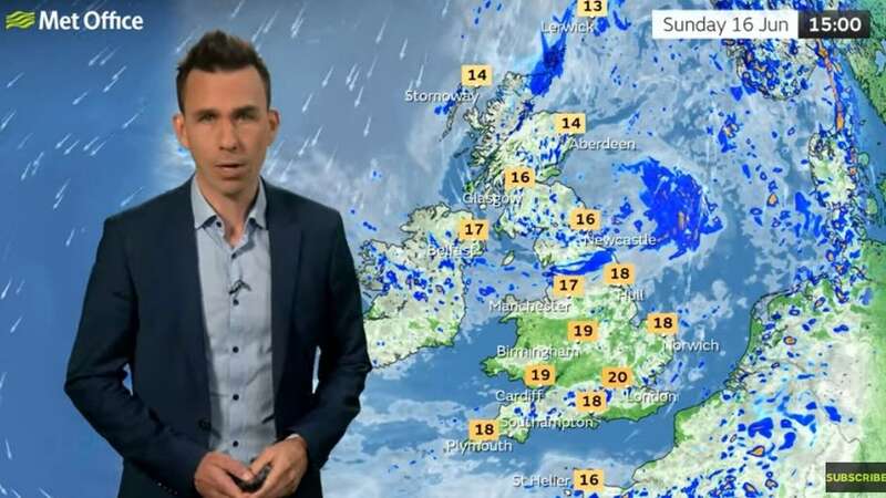
A weather striking map has shown the different temperatures the UK is facing over a few days as a period of low pressure causes havoc over our skies.
A low pressure system moving in from the Atlantic and the positioning of the jet stream south of the country means we are set for plenty of showers. Sadly, the gloomy outlook will not improve either over the coming 10 days with the forecasting plenty of showers on their way today and into the weekend.
Most of the UK is facing heavy downpours and thunderstorms today. As well as the rain, there will also be a drastic change in the temperatures since the middle of the week, as the mercury takes a sudden tumble.
In an update, Met Office meteorologist Aidan McGovern said: “A change in the weather patterns is on the way but I suspect it will be a change which won’t be widely popular. For more than a week we’ve had northerly winds dominating things and brought below average temperatures and frequent showers in a few spots.
 People are going to need umbrellas over the coming days (PA)
“To the west of the Atlantic there’s a branch of a jet stream which over the next 24 hours is going to pick up an area of low pressure and send it towards the UK. It will culminate in a cold front warm front combo bringing persistent rain for a time.
 Queen honoured in London New Year's fireworks before turning into King Charles
“On Friday we have that low pressure in place over the top of the UK., the jet stream once again to the south of the UK. That means we have an upper level low and a surface area of low pressure coincident with each other . The surface low, the upper low and a strong sun at this time of year, all the ingredients there for rapidly rising air currents, beefy shower clouds and torrential downpours - even some thunderstorms on Friday.
“A lot of showers to come after the band of rain on Thursday. We’re going to see frequent showers across the UK. Temperatures are rising, particularly in the east, with a lot of cloud.
“One other thing that is going to change over the next few days , as well as increasingly heavy downpours, are the temperatures. Some parts of the east of England are more than 6C higher than Wednesday.”
For today’s outlook, the Met’s forecast reads: “Outbreaks of rain becoming slow moving across northern Scotland and Shetland where winds will also be gusty. Elsewhere after a bright start, showers developing widely, these becoming heavy and perhaps thundery during the afternoon. Remaining on the cool side.
Tonight, More persistent rain across Shetland slow to clear north. Showers continuing to affect most areas, but becoming less frequent across parts of Scotland. Chilly under longer clear spells.
“After a chilly start for some, Saturday promises a day of sunny spells and showers, these locally heavy, with a continued risk of thunder, still feeling rather cool.”
Read more similar news:
Comments:
comments powered by Disqus