The Met Office has forecast the weather over the next 10 days as Storm Ciarán arrives in the UK with 110mph wind and three inches of rain expected.
Two amber wind warnings, the second highest level of alert, are in place for parts of the south coast of England for when the named storm hits on Thursday (November 2), together with further yellow rain warnings, a lower level which means some disruption could be on the way.
Met Office spokesman Oli Claydon said today the storm is "forming as we speak" and will hit this evening, with coastal gusts of 70mph to 80mph and the potential for 85mph. And people are being urged not to go near the water's edge due to "very dangerous conditions". Up to 80mm of rain could fall in parts of the country.
Shipping forecasts say gusts of 98mph could hit the Channel islands this evening, with wind speeds of up to 110mph in the middle of the English Channel. In England, there are at least 24 flood warnings - where flooding is expected - and 113 flood alerts - where flooding is possible. Scotland has eight flood warnings and one flood alert, while Wales has been issued one flood warning and 14 flood alerts. There are currently eight weather warnings in place across the UK which span the next three days.
An amber warning is in place from 3am to 11am in Cornwall and Devon, with the Met Office predicting Storm Ciaran will bring winds of 75mph to 85mph, with 65mph to 75mph gusts inland. Across the south coast, the amber warning runs from 6am to 5pm, with winds expected to reach 70mph to 80mph, with the potential for 85mph and large waves.
 Queen honoured in London New Year's fireworks before turning into King Charles
To follow the Mirror's live Storm Ciarán blog click here
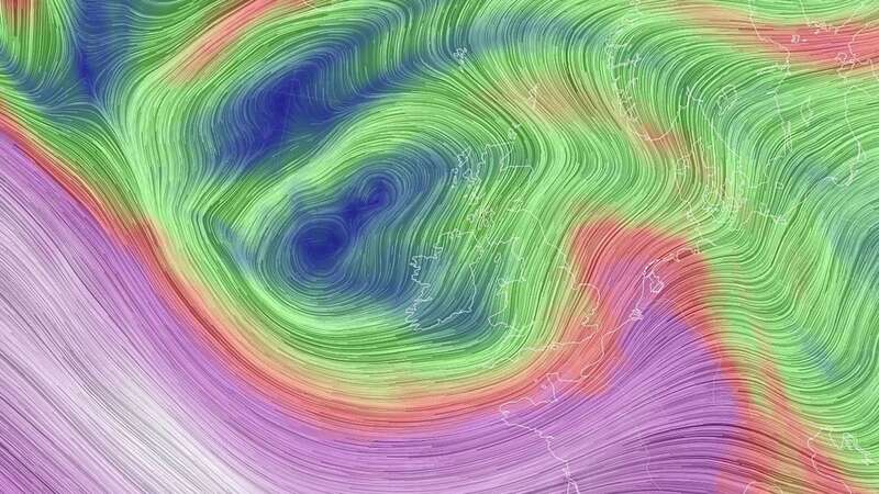
 Storm Ciarán is set to batter the UK until the weekend (GFS/ NCEP/USNWS/SWNS)
People are being urged by the Environment Agency to prepare for "possible significant flooding" across parts of England from Wednesday to Friday, with some significant coastal impacts also possible but not expected on Thursday. The mobile barriers at Exeter, which are part of the flood defence scheme, are being deployed and demountable and temporary barriers are already in place or ready to be installed along the River Severn.
Met Office Deputy Chief Meteorologist, Brent Walker, said: “Wind and rain warnings associated with Storm Ciarán are in force from tonight through until Friday, with further updates possible. These include Amber warnings for wind for parts of southwest England on Thursday morning and the far south and southeast of England Thursday daytime and early evening.
“Very strong winds are expected along southern coastal areas of England in particular, where gusts of 70 to 80mph are possible, perhaps exceeding 85 mph in a few exposed locations. Further inland, gusts could reach up to 50 or 60mph.
“As well as strong winds, there will be heavy rain across many parts of the UK. Much of southern and western England, Wales, northeast England and eastern Scotland look to see the wettest conditions between Wednesday evening and Friday morning. 20-30 mm of rain is likely to fall quite widely, with 40-60 mm possible over higher ground. Some parts of Wales and southwest England may see 80 mm of rain. This rain will fall on already saturated ground, bringing the risk of flooding.”
Met Office Deputy Chief Meteorologist, Brent Walker, said: “Once Storm Ciarán has passed, the weather over the weekend continues to look unsettled for many with more showers and rain at times. Warnings will continue to be updated over the coming days, so it is important to stay up to date with the Met Office forecast in your area.”
Storm Ciarán comes on the back of what was provisionally the joint-sixth wettest October on record for the UK, according to the latest Met Office statistics. The Met Office long-range weather forecast, covering Monday, November 5 to Wednesday, November 15, says: "Sunny spells and showers to start next week, with the heaviest and most frequent showers probably across western and northwestern areas where more persistent rain will be likely at times. It is likely to be breezy too at times, with gales possible around exposed coasts.
"The unsettled conditions are likely extend through the first half of November with further periods of rain and strong winds. However, as we move towards the middle of the month there is the possibility of slightly more settled, drier conditions developing for parts of the country, particularly further to the north. There is also the risk of colder temperatures, particularly overnight, though nothing unusually cold for the time of year is currently signalled."
Read more similar news:
Comments:
comments powered by Disqus